Fishing Vessels as Ships of Opportunity
The IMOS Fishing Vessels as Ships of Opportunity sub-Facility works with the fishing industry to collect near real-time subsurface sea temperature measurements by installing equipment on fishing gear deployed by a network of commercial fishing vessels.
Every day, fishing vessels operate broadly across coastal, shelf and offshore waters within Australia’s Exclusive Economic Zone. The IMOS Fishing Vessels as Ships of Opportunity sub-Facility utilises this opportunity to fill data gaps cost-effectively and increase the spatial and temporal resolution of subsurface sea temperature observations in Australia’s marine estate.
How it works
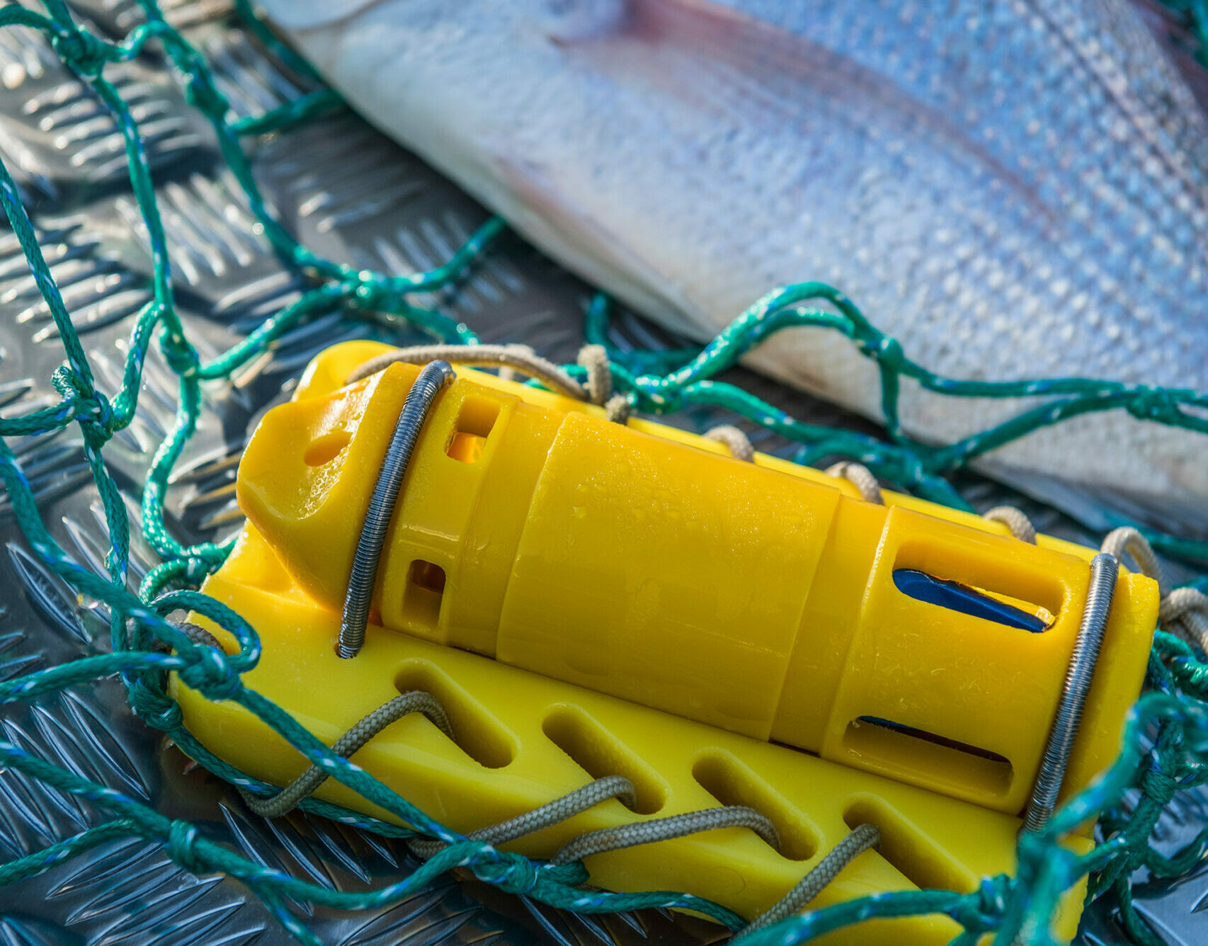
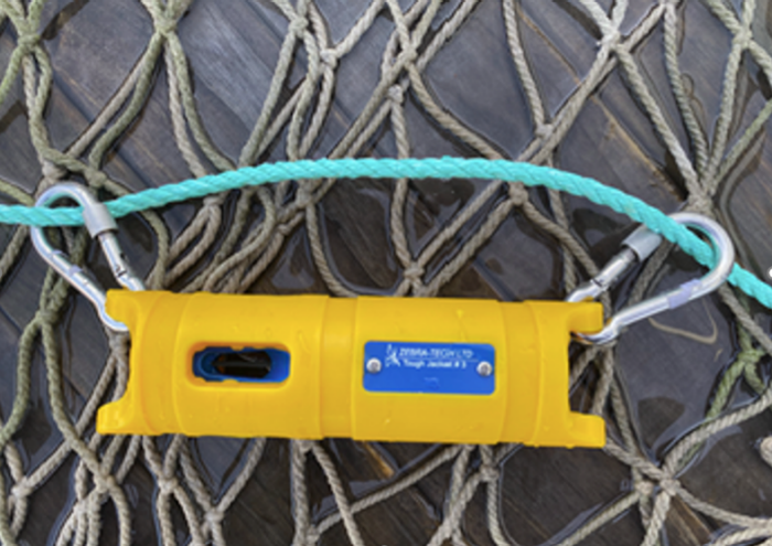
Compact, calibrated, low-cost sea temperature sensors are attached to a range of commercial fishing gear (including trawls, scallop dredges, demersal and pelagic longlines, gillnets, prawn trawl nets, purse and Danish seine nets, traps, and squid jig gear), which collect highly accurate sea temperature at depth measurements. Sensors can also be deployed by recreational fishers, Sea Country rangers and citizen scientists.
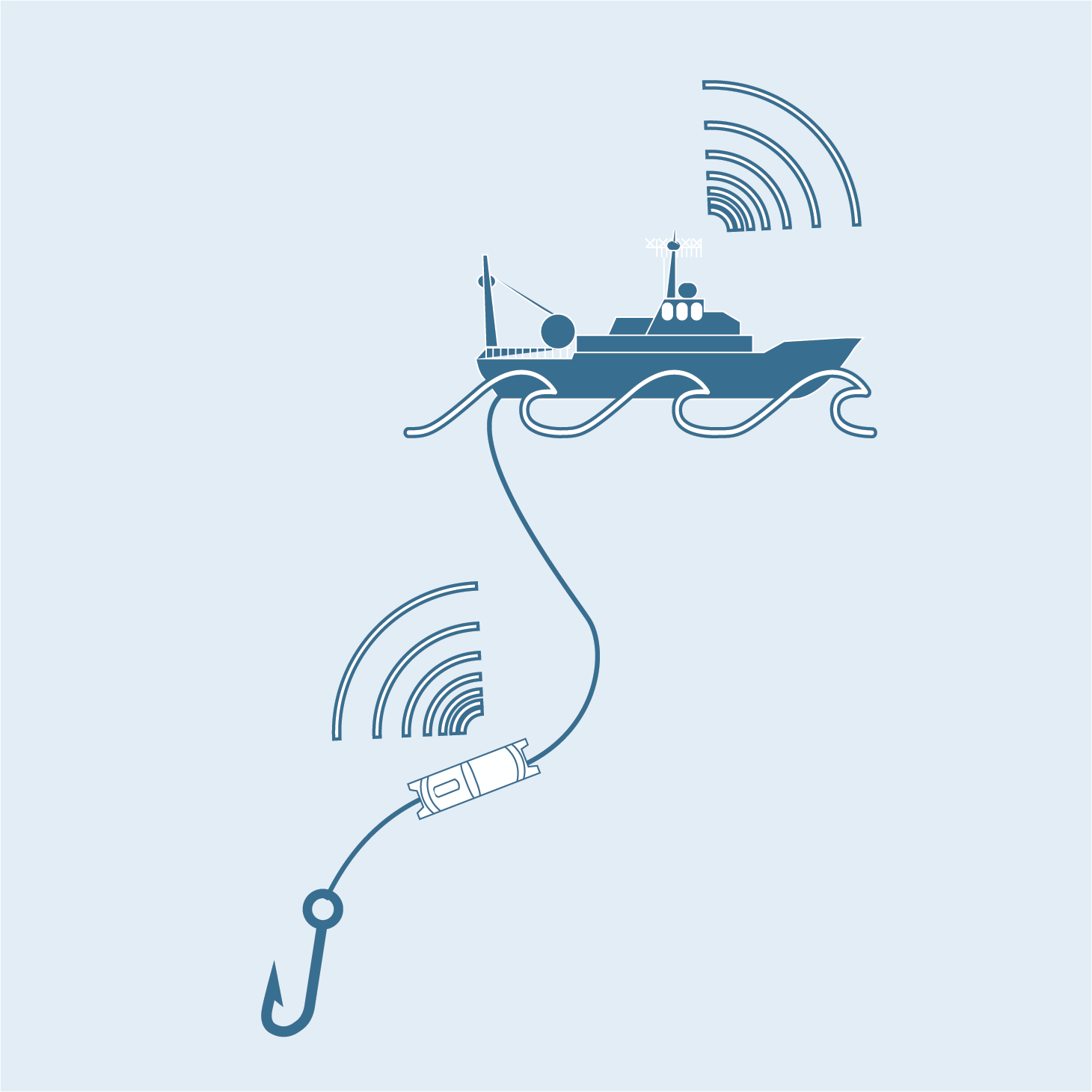
The sensors operate with minimal human intervention and communicate directly to a solar powered deck box, transmitting data in near real-time via phone signal or the vessel’s Wi-Fi (when available).
Data collection
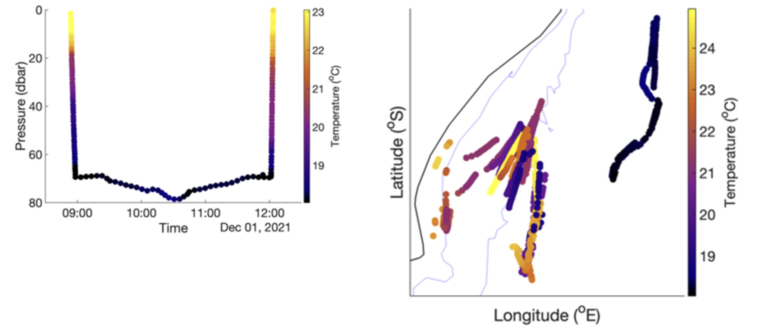
Time, position, depth, and sea temperature data are recorded when the sensor is deployed. When the sensor is returned on board these data are then transferred via Bluetooth to a solar-powered deck box installed on the vessel and forwarded to the IMOS sub-Facility for data processing. The data are then quality controlled with any identifying vessel information removed, before being transferred to the IMOS Australian Ocean Data Network (AODN) in near real-time for uptake.
A report summarising the data collected on a vessel is emailed back to the participating fisher for their own information, usually within 24 hours, enabling skippers to relate their (private) catch information to temperature-at-depth information.
Why it’s important
The data fill a strategic gap in the observing system, allowing stakeholders from across the blue economy to contribute to data collection and understand the oceans better. Potential beneficiaries include: the fishing community, fisheries managers, meteorological services and the research community.
In the long term, the data will help our understanding of the changing marine environment and its impact on life in/around the oceans. It will also provide oceanographers with quality-controlled data on an unprecedented scale for ground-truthing coastal models and to improve analysis and forecasts of oceanic conditions.
Useful Information
How does it work?
Sensor attaches to fishing gear
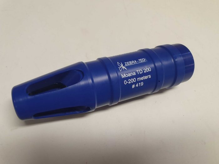
Our technology partner, Zebra-Tech, has developed a compact, low-cost temperature sensor (the Moana sensor) that can be attached to many types of commercial or recreational fishing gear. It operates with minimal human intervention and communicates directly to a solar powered deck box.
Fishers collect ocean temperatures
Fishers have always been ocean experts. The Moana sensor puts ocean data collection back into the hands of those who work on, and depend upon, the sea.
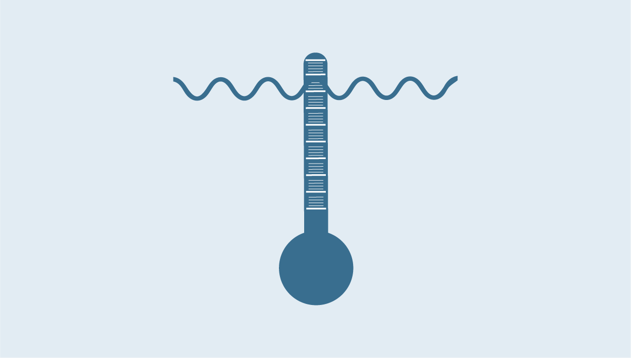
We need subsurface marine measurements to understand how the ocean is changing below the surface. International ocean observing programmes such as Argo, opens in a new window provide some deepwater data offshore but our subsurface coastal waters are not well monitored. Fishing vessels operate in areas where we have few subsurface ocean measurements, and where environmental change is having a huge impact.
There are thousands of vessels operating around Australia and across the South Pacific. This network of fishing vessels can collectively provide cost-effective, real-time subsurface data in our vast EEZ and beyond.
What are we asking fishers to do?
Participating fishers deploy small self-contained temperature sensors on their fishing gear, and a standalone, solar-powered deck unit on the vessel.
The sensor collects data every time the gear is deployed. After the installation, the system needs little to no intervention.
What do fishers get in return?
You will be able to access your individual vessel temperature data (with pressure and time). Sensor measurements will be made available online as downloadable files and sent to you via email within 1 hour of data reception.
You can compare sensor data with your personal catch information and understand relationships between catch and temperature.
The data will benefit fisheries and fishers
We are working to further the understanding of the link between water temperature at depth and fish distribution and abundance. The fishing industry can provide very valuable ocean observations on an unprecedented scale, which can be used to answer a range of questions. We can use the data in near real time to improve our ocean forecast models.
In the longer term, we hope the data will assist in standardising catch rates in our fisheries stock assessment models. Furthermore, better ocean data will improve our understanding of general ocean warming, marine heatwave events, temperature impacts on the relative or total abundance of species, species range shift, and the impact of this on fisheries productivity.
Travelling with the instrumentation
Download a copy of the information sheets below, and keep them with you when travelling with the moana sensor and deckbox to assist in responding to questions from transit officials:
Frequently asked questions for fishers
Can I attached the sensor to any type of fishing gear?
We can attach the sensors to longlines, netting, pots, and trawling equipment. We have a range of protective housings and brackets to simplify sensor mounting.
What data are collected?
The only information collected and shared will be temperature, depth, time and position at regular intervals during your fishing operations. Detailed vertical temperature profile measuring every 1m depth between the surface and 200m, every 4m between 200m and 1000m on the way up and down, and data every 5 mins while at a constant depth (such as in a pot, or on a line).
What about catch information?
No catch information is collected or shared. This is your private information and we do not have access to it.
How are the data offloaded?
When the Moana sensor comes out of the water, it automatically offloads its data via Bluetooth to a small, standalone, weather-proof, deck unit. You do not need to do anything during this process. Data are then automatically transferred to our secure, cloud-based servers.
Where are the measurements stored?
Data are anonymised and then sent to directly to the global telecommunications system where they can be accessed only by authorised national weather services (e.g. BoM). They use the data in their ocean models to improve tomorrow’s ocean and atmospheric forecasts.
For example, knowing the temperature of the upper ocean can help us predict cyclone tracks more accurately. Additionally, the temperature data are stored on our UNSW database for processing before being publicly shared anonymously, under the Creative Commons License 4.0 through IMOS on the Australian Ocean Data Network (AODN).
Measurements collected by the sensor are emailed back to the vessel that collected them within 1 hour of reception as a plot and in spreadsheet format.
Will you send details of my fishing to others?
We will share the temperature, depth, time and position data collected publicly on the AODN under the Creative Commons License 4.0. If you are concerned about your fishing location being shared, please speak with us before installing the sensor and deck unit.
How long will the sensor be on my vessel?
We will establish this upfront. The sensor’s battery lasts for two years, after which you will need to send it back to us for battery change and recalibration.
What does it cost?
The data pathway is funded by IMOS, but we require industry co-investment to cover equipment purchase and operating costs. Factors such as the number of sensors affect the degree of co-investment required. If you’d like to discuss entry to the project, email [email protected] or fill out our expression of interest form via this link.
Operating institution
Sydney Institute of Marine Science (SIMS)
Co-investors
University of New South Wales (UNSW) · Australian Fisheries Management Authority (AFMA) · Fisheries Research and Development Corporation (FRDC) · Northern Territory Fisheries · New South Wales Fisheries · Fishwell Consulting · Sunshine Coast University (SCU) · Ocean Data Network · Charles Darwin University (CDU) · Fishing Vessel Observing Network (FVON)


Acknowledging IMOS
Users of IMOS data are required to clearly acknowledge the source material by including the following statement:
Australia’s Integrated Marine Observing System (IMOS) is enabled by the National Collaborative Research Infrastructure Strategy (NCRIS). It is operated by a consortium of institutions as an unincorporated joint venture, with the University of Tasmania as Lead Agent.