Sea Surface Temperature Products
Sea Surface Temperature Products
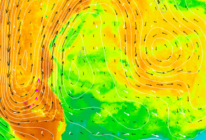
The Sea Surface Temperature (SST) Satellite Remote Sensing Sub-Facility in a collaborative effort with the Australian Bureau of Meteorology produce high-resolution satellite sea surface temperature (SST) products over the Australian and Southern Ocean regions, designed to suit a range of operational and research applications. All these products follow the latest International Group for High Resolution Sea Surface Temperature (GHRSST) “GDS 2” file formats, assisting international data exchange and collaboration. Information describing the different types of IMOS GHRSST data products, their derivation, validation, and how to read and use the contents of the data files, can be found below.


Data
The highest spatial resolution (1.1 km x 1.1 km) data from Advanced Very High Resolution Radiometer (AVHRR) sensors on NOAA Polar-orbiting Operational Environmental Satellites (POES) can only be obtained through receiving direct broadcast High Resolution Picture Transmission (HRPT) data from the satellite. In Australia, HRPT data is received by a number of agencies (Bureau of Meteorology, Geoscience Australia, AIMS and CSIRO) and consortia (WASTAC and TERSS) at reception stations located in Darwin, Townsville, Melbourne, Hobart, Perth and Alice Springs and in Antarctica at Casey and Davis Stations.

Useful information
Operating institution


Acknowledging IMOS
Users of IMOS data are required to clearly acknowledge the source material by including the following statement:
Australia’s Integrated Marine Observing System (IMOS) is enabled by the National Collaborative Research Infrastructure Strategy (NCRIS). It is operated by a consortium of institutions as an unincorporated joint venture, with the University of Tasmania as Lead Agent.